Ross Island
Type: Academic
School: KRVIA, University of Mumbai
Year: 2017-18
Advisor: Ainsley Lewis, Nikhil Khadilkar &
Sonal Sundarajan
Software: Q-GIS, Autocad, Rhinoceros, Sketchup, Lumion, V-Ray, Photoshop, Premiere Pro, Indesign & Illustrator
South Andaman, India
Project Description
The proposed project seeks to undertake a comprehensive appraisal and embrace the submergence of Ross Island in the Andaman region, while simultaneously commemorating the island’s journey into a state of dystopia. By striking a delicate balance between nature, architecture, and history, the project aims to celebrate the diverse epochs witnessed by the island. It will also explore the response of both the inhabitants and the Indian navy to the challenges posed by climate change, as they adapt to the island’s imminent descent into oblivion.
Throughout its existence, Ross Island has become a repository of historical remnants, capturing the essence of time, space, and collective memory from various eras. Presently uninhabited, the island has piqued the interest of the Indian navy, which envisions transforming it into a naval depot owing to its strategic geographic location. However, this project endeavors to establish a symbol of remembrance for the surrounding community—a beacon that not only guides but also documents the island’s profound history and its inescapable demise.

Vignette of the different eras on Ross island

Topography Study Models

Topography Study Illustrations
Master Plan
The master plan focuses on delaying the sink of the island by adapting various landscaping strategies to boost the growth of the coral reefs that prevent the weathering of the soil. The pavilions are strategically situated on the island that is dedicated to each era that the island had witnessed. These pavilions would gradually sink over time, repeating the chronology of the epochs. The main observatory is situated on the highest part of the island that primarily caters to the defense (Indian Navy) and helps to study and examine the consequences of climate change.
The existing ruins are connected with nature trails connecting with the instruments scattered all along the island. These instruments help the observatory to study the natural phenomenon. Also, the instruments mark the extent of the island that will still act as a beacon for the local people on the mainland Port Blair.
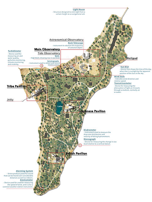
Masterplan of Ross Island

Proposed master plan for different intervals of years predicting the loss of foot print

Wall Section, Main Observatory model & Section cutting through the tribal pavilion
Recognition
Winner - 2021 Data Urbanism Design Scholarship Award
by Institute for Advanced Architecture of Catalonia, Barcelona
Winner - Best Bachelors Thesis Award 2019
by Unfuse International Architecture Thesis Award, New Delhi
Joint Winner - MIMANSA Best Thesis Award 2018
by Indian Education Society School of Architecture, Mumbai
Citation - Kamla Raheja Memorial Award 2018
by Kamla Raheja Vidyanidhi Institute for Architecture, Mumbai